TUCSON, Ariz. (KGUN) — Just as many of us are cleaning up and recovering from last week’s thunderstorms and flooding, another low pressure system will arrive to bring us another busy monsoon stretch.
This next system isn’t as strong but will still create strong thunderstorms capable of producing damaging wind, heavy rain, small hail and bringing flooding back to the region.

This disturbance will combine with abundant moisture to produce widespread thunderstorms Thursday, Friday and Saturday. Not everyone will see rain as this next system passes by, but we all have a chance of getting some more rain. Most models are predicting anywhere from 0.10” all the way up to over an inch of rain over the 3-day period. However, isolated thunderstorms will be capable of producing even heavier amounts of rain in a short time.
This comes as we prepare to bring a very productive July to a close. In Tucson, we have already set a new record for the wettest July ever recorded! At Tucson International Airport, the official reporting station, we have recorded 7.08” of rain since the first of the month and we will likely add to that total before the month comes to an end. This breaks the old record for the month which was set back in July of 2017 when 6.80” was recorded.
Not only have we already broken the record for the wettest July ever recorded in Tucson, we actually have a chance to break the record for the wettest month ever recorded. The wettest month ever recorded was August of 1955 when 7.93” of rain fell. We’re within an inch of breaking the record and this next system may provide enough rain to do it!

July has treated us extremely well with plenty of rain and we can finally say we’re above average for the year. Unfortunately, we don’t like to see too much rain in too short of time because of the dangerous flooding it creates that sometimes ends in tragedy. The flooding also leaves behind a big mess for many residents to clean up. However, despite all of this, the heavy rain has helped to bring much needed relief to our parched desert.
In June, our precipitation page was looking pretty bleak. We were well below average rainfall and drought was continuing to grow. Our confidence in getting any significant rain was waning because of the dismal monsoon we had in 2020. Now, as we get closer to the end of the month, we can be much happier about our precipitation page. We can’t get too excited because we still need more rain to help erase deficits from the past two years and to help fill reservoirs that are running precariously low. July has been a blessing and, hopefully, August will treat us to more beneficial rain.

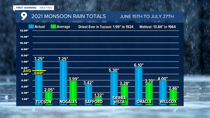
Tucson isn’t the only location recording above average rainfall for monsoon. Most southern Arizona communities are reporting rain totals that are, so far, above average for monsoon. Keep in mind, the revised average monsoon rainfall total for Tucson is 5.69”. We have already eclipsed that with over 7” of rain as I write this article.

The outlook remains favorable for monsoon to stay relatively active as we head into the month of August. As many of us know, monsoon can be fickle and can suddenly turn its back on us only to leave us wondering what happened to the thunderstorms that were bringing so much rain. We’ll see how much rain August brings, but it’s nice knowing we’re already above average for monsoon and we’ve finally gone above average for the year. Let’s hope we can keep the trend going!
Until then, please be careful as the next round of thunderstorms rumbles across Arizona. With the ground already saturated, it won’t take much rain to get the washes running swiftly. As we always like to remind you... Turn Around, Don’t Drown!


