




(KNXV) — Evacuation orders and road closures are in effect for multiple areas of the region due to flash flooding.
ROAD CLOSURES:
A portion of Interstate 17 was impacted by flooding Sunday, but was reopened just before 3 p.m., according to the Arizona Department of Transportation.
ADOT officials say the following highways remained closed as of early Monday morning:
- State Route 89A between Sedona and Kachina Village (mileposts 375-397)*
- State Route 73 between Indian Pine and White River (mileposts 357-351)
- State Route 238 between Maricopa and Gila Bend
- State Route 288 between mileposts 271-302
- State Route 179 in Sedona (milepost 313)
- State Route 377 northbound north of Heber-Overgaard (mileposts 1-13)
*SR 89A in Oak Creek Canyon closed to all through traffic until further notice. Canyon residents may travel into and out of Sedona for goods and services
In Flagstaff, motorists are being warned of the following flood-related road closures:
- S Milton Road
- Route 66
- Butler Avenue
- E Huntington Drive
- S Lone Tree Road
EVACUATION ORDERS:
Due to the potential for flooding in and around the Lewis Subdivision in Holbrook, residents are being advised to move to SET status.
WEEKEND RESCUE MISSIONS:
Ranger helicopter crews conducted 27 rescue missions across the state over the weekend due to the weather, according to AZ DPS.
On Sunday, crews assisted the Sedona Fire District with extracting and rescuing 18 people along the Oak Creek area.
In southern Arizona, on Sunday, the Pima County Sheriff's Office requested assistance in rescuing two individuals, officials stated.
Navajo County Emergency Management & Preparedness said Monday morning: "Winslow Area Residents along the Little Colorado River in Ames and Bushman Acres need to 'GO!', evacuate now. The water levels are rising. Get your family, pets/animals, and leave now. Go to higher ground and a shelter will be advised as soon as possible."
The Town of Clifton sent out an evacuation notice early Monday morning with an evacuation center at Greenlee County Fairgrounds (1248 Fairgrounds Road, Duncan, Arizona, 85534). The evacuation notice and flood warnings were lifted and canceled around 5:30 a.m., saying:
"EVACUATION NOTICE IS LIFTED. FLOOD WARNINGS HAVE BEEN CANCELLED.
The evacuation notice for North Clifton, Park Avenue, and the North Clifton RV Park has been lifted.
According to the National Water Prediction Service, the San Francisco River has peaked in Clifton, and water levels are now receding.
Public safety personnel will continue monitoring water levels over the next few hours.
Thank you for your cooperation and patience."
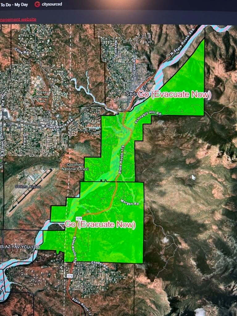
City of Sedona officials said Evacuation Zones 8, 9, and 10 were placed under a “GO STATUS” on Sunday, which means anyone in those areas must leave immediately.
An evacuation center was set up at Sedona Red Rock High School (995 Upper Red Rock Loop Rd.).
City officials added Oak Creek is “rising quickly,” reminding citizens to avoid creek beds and washes, and not to cross rushing water that is on the road.
Complete information on Sedona evacuation orders can be found online.
Cedar Creek residents along the river were also under a “GO” evacuation order Sunday morning, with Canyon Day Junior High established as an evacuation center.
The White Mountain Tribe EOC said in a social media post: “Residents along River Rd. are now placed on "Set" status. Please prepare to leave your homes quickly if water levels continue to rise. Pack medication, clothes, charge your phones, flashlights, and other essential items you will need. Know your exit routes and check on elderly and neighbors.”
Additionally, sheriff's officials said Lone Pine Dam Road at Linden Wash in Linden was shut down because of flooding.
On Monday morning, Gila County officials said, "The GO evacuation orders issued due to flooding have been lifted for all affected areas, including Gisela, Tonto Basin, Sleepy Hollow RV Park, Lazy JR, Greenback Valley RV Park, and other affected locations. The floodwaters that prompted these orders have receded. Residents may return where access is open. Continue to obey road closures, barricades, and instructions from public safety personnel."
An evacuation shelter was established at Tonto Basin Elementary School (445 S. Old Hwy 188).
On Monday morning, the Town of Camp Verde released the following Flash Flood Warning: "THIS IS A SET MESSAGE FOR RESIDENTS: STAGECOACH AND HORSESHOE BEND -CAMP VERDE MARSHAL'S OFFICE IS ENCOURAGING RESIDENTS TO VOLUNTARILY EVACUATE DUE TO RISING FLOOD WATER."
The Camp Verde Marshal’s Office notified residents near Verde River, West Clear Creek, and Wet Beaver Creek on Sunday to immediately evacuate due to flooding.
A shelter is available for evacuees at Camp Verde Parks and Recreation Gym (473 Main St.).
COUNTY EMERGENCIES:
On Sunday, Coconino County officials activated the Emergency Operations Center as flooding hits the region.
With the activation of the EOC, a call center (928-679-8525) is in place with updated information on evacuations, road closures, and sandbags.
County officials say sandbags can be obtained at Pinewood Fire Department (475 E. Pinewood Blvd.) and Highlands Fire Department (3350 Old Munds Hwy.).
Additionally, residents can fill their own sandbags at Thorpe Park (parking lot at north end of N. Aztec St., between Frances Short Pond and softball fields). Residents are advised to bring their own shovels.
As a regional Flood Watch continues, county updates can be found here.
The EOC activation comes two days after Gov. Hobbs declared a state of emergency for both Coconino and Navajo counties.
